Showing posts with label wti. Show all posts

Friday, June 1, 2012

GPS against Theft


Theft occurs adamantly unpredictable. Devices which one can put or install in his/her assets can help in preventing possible robbery. Information about the robbery "hot spots" will also be a big help in one's preventive measures. 

Sample tracking report provided by WTI
Theft cases range from fuel thieving from trucks (loading petroleum/fuel tanks) to stealing the whole truck. As an industry concerned and in line with the prevention of such circumstance, WTI aims for the safety of everyone. For inquiries on how to avail tracking and security devices for asset management, just contact WTI through info@findme.com.ph or call us at (02) 441-0016 to 23.

Everyday, usual as it may be, businessmen should always be prepared and secured with their assets. Because at the end of the day, everyone must face the reality that possible crimes and theft doesn't exempt any special day or occasion.

Thursday, May 31, 2012

Parents, GPS for your Driving Child's Safety

Here's a fact,


In 2009, reported number of death among teen drivers (ages range from 16 to 19) in the United States is eight, as reported by the Centers for Disease Control and Preventionone of the major operating components of the Department of Health and Human Services in the United States.


Photo Source: Flickr.com

As quoted from CDC website

How big is the problem?

In 2009, about 3,000 teens in the United States aged 15–19 were killed and  more than 350,000 were treated in emergency departments for injuries suffered in motor-vehicle crashes.1,2  
Young people ages 15-24 represent only 14% of the U.S. population. However, they account for 30% ($19 billion) of the total costs of motor vehicle injuries among males and 28% ($7 billion) of the total costs of motor vehicle injuries among females.3
References
  1. Centers for Disease Control and Prevention. Web-based Injury Statistics Query and Reporting System (WISQARS) [Online]. (2010). National Center for Injury Prevention and Control, Centers for Disease Control and Prevention (producer). [Cited 2010 Oct 18].
  2. NHTSA[2009]. Fatality Analysis Reporting System (FARS), 2009. Washington, DC: U.S. Department of Transportation, National Highway Traffic Safety Administration, National Center for Statistics and Analysis.
  3. Finkelstein EA, Corso PS, Miller TR, Associates. Incidence and Economic Burden of Injuries in the United States. New York: Oxford University Press; 2006.
Given the following facts, teenage vehicular crashes can be easily prevented through different strategies and GPS devices can help as such.

GPS tracking device installation in your child's vehicle will help you determine the whereabouts, monitor your child's running speed, harsh brakes, and the sort. Through the following alerts, you can contact and remind your child for precaution.


Tracking System offered by Globe Telco

What does it take for someone decide about using a tracker or a tracking system?

There will be one and only answer to this question, VALUE. People tend to track objects or even people because they value the object or the person (I can be very generalizing with this idea).

As mentioned in the earlier articles, some GPS applications are now offered to public for free. This does not mean that I am about to mention a free Tracker is now offered publicly. Though not free, Globe is offering a Tracker to locate people or even mobiles to their network subscribers.

The Tracker works to locate anyone anywhere across the Philippines, which surely be beneficial to individuals with different reasons why it does. It is in low cost, Php2.50 to Php5.00 and we should acknowledge about its limitations.

Photo source Globe.com

Global Positioning System in the Philipines


Photo shows how WTI TrackMe combine all the useful aspects into a quality GPS service and tool

In the Philippines, only few companies were able to develop and maintain products and services which primarily utilize the Global Positioning System (GPS)Geographic Information System (GIS), and Telemetry System.


Tracking and management system through the GPS technology has been helpful to most industries for more than a decade now. It is a misconception for some that GPS technology is a newbie in the country since pioneer companies has been operating and supporting the key Philippine business players longer than what people think.


Nowadays, GPS utilization in the Philippines by businesses and individuals significantly increases as the need and benefits become more and more essential. Partnership with companies which commercially offer digital maps, asset tracking and monitoring systems will greatly help an industry especially those which need Fleet ManagementVehicle Tracking, and Security assistance.

Wednesday, May 30, 2012

Poor Fleet Management


Manual Fleet Management System is a source of headache Source: Flickr.com

That is the reason why Fleet Management is a vital character in a Fleet Management Scenario. With the proper use of technology, some companies are able to develop the Fleet Management System and backs up the key economic players from different industries. 


Because in REALITYexisting Fleet System has a lot of limitations:

Inaccurate Management Report Accuracy in data encoding (trip tickets, for example can be easily modified) and scaling up is an important concern. Human error is very rampant on manual data logging which may have a great effect on any business operation.

Inefficient Fleet Capacity Distribution Time lapse on manual data encoding, analysis and feedback approximately takes two months. Consequently, immediate data of vehicle usage including an overview on how the entire fleet is being used and maximized is not readily available. Thus, fleet managers become inefficient in determining their fleet distribution.

Increased Gas Consumption and Inefficiency Provision of data during vehicle on transit is not available since the idling time and side trips can’t be checked by a manual system. Routes are not being maximized resulting to inefficient and increased gas consumption.

Increased Asset Damage and Accident Manual system has no means of monitoring safe driving standards, over speeding, harsh braking and harsh acceleration, and vehicle usage efficiency. Poor consequence management on fleet manager’s end is expected.

Being in the IDEAL Fleet Management Scenario is not that hard, if a Fleet Manager has a combination of properly developed technology, system, and service.

Weather Monitoring in the Philippines


As a technology-based company, WTI’s involvement on climate change adaptation covers such products and services which help other industries adapt with the climate and weatheralterations as well. These product and services vary depending on the setting (rural or urban) and on the need of the industry (whether the partner organization is agriculture-based or commercial-technology-service based).
Photo Source: Flickr.com
Philippines is an agricultural country and it is not a new fact that almost all Filipinos depend on land and water to live – from food to eat, water to drink, plants which could be the sources of materials for clothing and shelter, herbs and medicines. With the importance of agri-business in our country, climate and weather condition play a significant role.

From the development and continuous success of WTI in GPS in the Philippines, WTI has successfully installed a network of AWMS in rural and urban setting where localized weather data are collected in real-time using Telemetry and GSMtechnology. The localized weather data includes wind speed, wind direction, temperature, rain fall and solar irradiation. This set of localized weather data is crucial to research and development, scientific government research and studies.  AWMS can generate baseline data, which are vital inputs to disaster management, adaptation to climate chance, among others.

The Farm Producer’s R&D is taking the lead in gathering ground weather data and spearheading the research and development on their crops variety, health, and yield.  Localized weather data are processed, analyzed and used for further studies such as crop suitability, soil analysis, weather pattern analysis, crop yield analysis. Farm Producers are now adapting modern farming techniques and now looking at tools using new technology that will aid them in realizing better farming practices and entering into e-micro-enterprises to promote and sell their produce in wider market.

In this undertaking, land is the main resource and food security are the issues that are being targeted.  It is the main goal of the local farmer to produce more good crops and put enough food in every family’s table and making agri-business sector profitable.

Tuesday, May 22, 2012

Better Business Operation with GPS System

Image of WTI's real time GPS tracking system

Service-based industries especially to businesses which process data of commercial vehicles or fleet management usually demand employees to work proficiently. But this need to meet a certain target of efficient business operations requires a much larger number of employees. With this, business operators usually find ways on how to use the existing technological aids to keep the productivity of such industries in high level.

As what Tracking System Direct mentioned in one of the articles in their website,
"With the current state of the economy, businesses simply cannot afford wasting financial resources on excessive fuel idling, poor route management or sloppy performance. This is why GPS monitoring devices for truck tracking will only continue to grow in demand."
GPS Tracking System helps a lot in businesses for it provide such aids which a typical manpower provides. GPS System enables fleet and other business owners oversee and manage assets as well as people without the physical presence on the location where these are located. In terms of access, a computer, laptop or tablet with internet connection or even a simple mobile phone is already enough for a business owner to look after the business

GPS in Business

With the era of technological advancement, it is wise to make use of the readily-available technology to make a business operation easier and more efficient. Webcast Technologies, Inc. (WTI) is here to help.

Know which SECTOR your business belongs
As WTI tailor fits a system depending on your need, below is a categorization of industries based on the goods and/or service offered:

·        Primary (includes businesses which extract directly from earth, includes farming, fishing, logging, and mining)
Development of weather castingtechnology helps plantation owners know when will be the best and worst time to plant crops. Companies whose main products are fruits and vegetables, such as Del Monte Philippines largely benefit with the weather monitoring system because with the proper use of the weather information, best quality and quantity of harvest is within reach.

Photo Source: Flickr.com, Cuba Gallery
·         Secondary (involves the processing and manufacturing of products from primary industries – factories)
Being sure that the products are in good condition and preventing these from being stolen are the reasons of the development of tracking and security systems. These systems help in the betterment of the business’ operations as well as to prevent losses of the company.

Photo Source: Flickr.com
·        Tertiary (service industry, including financial institutions, transport, restaurants, etc.)
For banks, money changers, pawnshops, and the sort, security is vital. Also, safe transportation of products from the factory to warehouses, to secured delivery of goods to consumers is important. Well-developed tracking and security system is what these type of businesses use for efficient management of their products.

Photo Source: Fleet Management System - Naxter Tech
·        Special Sector (includes intellectual services – IT, research, etc.)
It is an industry which is knowledge-based. Meetings, conferences, and the sort are very much important for this sector. Nowadays, technology has aided the primary problems of being late for appointments and meetings due to heavy traffic and tight schedules through an efficient video communication. Video conferencing at its best of course requires the best equipment and finest system.

Photo Source: Flickr.com
Research industries on the other hand will competently run through the developed GIS, GPS, GSM, SMS, GPRS, Telemetry technologies. 


Adventurer's GPS

Photo Source: Flickr.com

The trend among the adventurous people come in different varieties including the gadgets they use. Outdoor activities like biking, hiking, trekking and the sort are among the activities which are GPS beneficiaries.

Coming from the trend of Geotrekking, a term "which grew organically from the community of people who were using their GPS systems to share routes, to share the locations of points of interest, and to share the locations of geocaches" (Wikipedia, 2012) is an earlier form of Geocaching.


According to geocaching.com, Geocaching is a real-world, outdoor treasure hunting game using GPS-enabled devices. Participants navigate to a specific set of GPS coordinates and then attempt to find the geocache (container) hidden at that location.


For geocaching, there are no such equipment a geocatcher will need. The only necessities are handheld GPS device or a GPS-enabled mobile phone so that you can navigate to the cache, and a Geocaching.com Membership. With this, different IT and GPS companies compete to offer handheld, light-weighed GPS devices to adventurers who find Geocaching a worthwhile and exciting activity.


For more information about the activity, just check out the site for the activity: geocaching.com


Monday, May 14, 2012

WTI's Automated Weather Monitoring System (AWMS) featured in Inquirer


Automated Weather Monitoring System (AWMS)

Dr. Corazon PB. Claudio of Philippine Daily Inquirer in her Changing Conditions   (sub-article to the main written work, Mapping the Future) describes how automated weather monitoring system is needed in strategic locations to monitor the changing environmental conditions. Webcast Technologies, Inc. (WTI), as mentioned, is the company which installed the weather monitoring system.

With WTI’s mantra “Winning Through Innovation”, WTI policies include initiatives on developing a climate change adaptation-related product, the solar-powered Automated Weather Monitoring System (AWMS).

WTI pursuits to continuous Winning Through Innovation efforts and as part of its Corporate Social Responsibility, WTI developed a product that supports initiatives towards adaptation to climate change.  In 2009, WTI started collaborating with the academe, the University of the Philippines National Institute of Geographical Science (UP-NIGS) through its COO, Mr. Bernardo F. Abis, together with Engr. Cecilia B. Pagba, GIS Head and GIS Business Development Manager.  WTI’s strong collaboration with the academe and various industry partners paved the way to the development and commercialization of solar-powered Automated Weather Monitoring System (AWMS).  At the onset of this initiative, the idea was to slowly build the infrastructure and installation of AWMS network in the country where localized weather data will be generated and shared among its stakeholders.

WTI in partnership with Google is creating a disaster preparedness tool using a Google-based platform, combining  GIS + GPS + Telemetry in a net based system, providing an accessible and complete data to all end users.

May is a Road Safety Month in the Philippines

Presidential Proclamation No. 115-A declares the month of May as Road Safety Month to promote road safety and raise awareness on the health impact and economic costs involved.

GPS devices with quality service have been very helpful to all the users not only in fleet management but also with the prevention of such accidents on roads through the harsh braking alert, speed monitoring capability, and the sort.  Talking about the road safety, the Global Road Safety Awareness Week is celebrated in different dates depending on each country's holiday. I
n the Philippines, the National Road Safety Awareness is celebrated  during the month of May. 


Along with WTI as a company offering devices and services for road safety and accident prevention, the Safety Organization of the Philippines or SOPI, a non-profit, non-governmental, national public service organization founded in 1959 which focuses on prevention of deaths and injuries which can possibly occur in workplace, homes, communities, and especially roads. SOPI promotes safety consciousness and accident prevention. With the organization's objectives, SOPI is holding its 42nd National Road Safety Convention and General Assembly on May 31 - June 1, 2012 at the Traders Hotel, 3001 Roxas Boulevard, Pasay City.


Posted below is a full detailed poster on the upcoming convention:


42nd National Road Safety Convention and General Assembly on May 31 - June 1, 2012
Photo Source: SOPI website

Thursday, May 10, 2012

GPS on Road

Track recording of monitored vehicles enables the user know the vehicle's whereabouts as well as its efficiency levels by reviewing the entire duration of the vehicles' travel, the idle points, harsh breaks, etc.

Though aware and users of the GPS technology (in different aspect), Philippines is not that GPS dependent when it comes to road navigation like in the United States. But let this article briefly discuss about how GPS devices help an individual get to a place without hassle in less time.

A dad from U.S. is about to watch his kids' football game. He and  his wife are GPS Insight users, and according to his blog, this is what he did:
"Here’s what I did using GPS Insight to get going within a minute (less than asking my wife for detailed directions or an address): [note that 477-477 is "GPS-GPS" and our 6 digit short code]"


  • Texted “gps nav2″ to get my wife’s location (she was just pulling in when I talked to her)
  • Texted “gps nav2 landmark flagfootball” to create a landmark named “flagfootball” within GPS Insight, corresponding to her location
  • Texted “gps rubi dis flagfootball” which told GPS Insight to dispatch my Garmin in my vehicle (Rubi is short for Rubicon) to the “flagfootball” location

  • Garmin takes me to "flagfootball"
    Photo Source: Getting to my kids’ Flag Football Game using GPS Insight blog
    GPS Insight receives time stamps and when the user chooses go, a visual turn by turn directions on how to reach the destination will be shown.

    With the help of a GPS device, the man arrived in the foot ball game venue in less time, without the hassle of bugging his wife about the directions of going to the venue.


    Wednesday, May 9, 2012

    GPS for Motorcycles and Bike Riders

    You read it right. GPS devices are much specialized than before. GPS companies around the world continuously research and develop GPS-utilizing devices and software for the benefit of its users.

    Phantom Tracking
    Photo Source: phantomtracking.com


    Phantom Tracking, a technology company from Southern California has developed a GPS motorcycle tracking/security system that protects not just the motorcycle but also the rider.

    Phantom Tracking claims that they are the first in the world  "to combine an anti-theft security/tracking system with a crash detection feature using GPS enabled technology. This technology allows Phantom Tracking to notify you if your motorcycle is being moved." (from phantomtracking.com website)


    Also, Phantom Tracking has an anti-theft and crash detection system in the world complexly furnished for motorcycles. 
    "Phantom Tracking is designed to give the rider complete peace of mind for the riders safety and the motorcycle’s security"
    To know more on how Phantom Tracking works, just click the link. 

    GPS' aid for Businesses

    Readings and information about GPS, its uses and benefits to the economy swarms in media - television and radio ads, newspapers, magazines, billboard ads, and other print outs, and most especially in new media, the internet.

    GPS Trackers are developed and used for vehicle tracking, helpful to fleet management system, and beneficial to fleet owners for theft prevention. 

    GPS Devices and Tracking systems can be termed as a Third Eye and/or Bird's Eye for it enables the device owner to track real time in a third eye and bird's eye view, as shown in the photo below.

    WTI's real time tracking screenshot

    Tuesday, May 8, 2012

    GPS in the Philippines

    GPS serves individuals and businesses of different industries in so many ways in the Philippines and in the whole world .


    Diagram on how WTI GPS device works

    Reason of using GPS may be intentional or not, it may be personal (to track loved ones and have peace of mind while they are on road) or professional (tracking of vehicles' whereabouts especially when managing a fleet, theft prevention, and the sort). Talking about involuntary usage of GPS, though there's no subscription on a user's end but knowingly or unknowingly, we are already using and utilizing such services and information generated by GPS technology ( in Agriculture & FarmingEmergency ResponseLaw Enforcement & PoliceAuto Sales & RentalsFishingRecreationBus & TaxiFleet Management & TrackingScience Field WorkCamera & PhotographyKids and PetsSports).

    Fast tracked development of digital technology benefited the entire world's population, in all aspectsRecreation, Health, Work, Relationships, Spiritual, Home, Education, and Financial. Obvious as it is, GPS passes through all the enumerated aspects of life

    With the given uses of GPS technology, one must know the reason of GPS usage and know to which entity should go and subscribe unto a GPS service

    In the Philippines, when it comes to GPS service provider, Webcast Technologies, Inc. is a great choice. For its more than a decade existence, WTI has been tried and tested when it comes to GPS device and service in the Philippines.


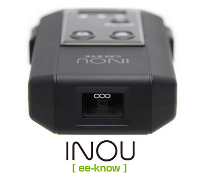
    INOU'S GPS Camera

    Photo Source: cateye.com


    "CatEye is proud to introduce two all-new ground breaking products. The CatEye INOU is the world's first GPS enabled camera and video recorder. Share your rides with the INOU Atlas website and seemless Twitter and Facebook integration."                      


    CatEye, a Japanese company, leading in manufacturing tools for cyclists such as cycle computers, lights and reflectors which are currently used around the world has come to another breakthrough. The CatEye INOU is the world's first GPS enabled camera and video recorder, available to the public for almost a year now.


    The GPS-enabled camera functions as a screen shot and video recorder of a cyclist's route from time to time. The footages     can be chosen whether for a minute by minute interval, depending on the mode the cyclist has chosen. 


    Though the gadget has no screen to display the recorded footages, it can be connected to a computer/mac after usage, browse through the INOU's website and finally, the user can view the recorded videos and shots.


    Everyday, GPS proves to be very useful to individuals of different interests. From its synchronization of time in mobile phones, to athletes, to housewives (who wish to track their children from time to time) to different businesses and industries. GPS is such a gift for humanity, as Dr. Parkinson has proven.


    Monday, May 7, 2012

    Parkinson: GPS for Humanity

    Through the Stanford Center for Professional Development, Dr. Bradford Parkinson, (chief  Architect of GPS system and Stanford Professor Emeritus of Aeronautics and Astronomics) has been honored and inducted as part of the Stanford Engineering Heroes Hall of Fame. 

    Stanford University, recognized as one of the leading universities in the world has recently held a 
    Stanford Engineering Hero Lecture, with GPS as the center of the talk. 


    Photo Source: gpsworld.com


    Dr. Parkinson talked about GPS, its origins and applications, and explored its future.

    GPS for Humanity is his talk's title. GPS' history and people with significant contribution on its development has been chronologically discussed, considering himself as a predecessor of the technology. His talk included how GPS now serves as a vital tool of the entire population's life. Cell phones, now considered as an important need by most individuals rely on GPS for timing, ships and aircrafts have a lot of GPS receivers to provide positioning information. It is also stated that other applications range from earth movement to disease tracking to search and rescue. 


    Importance of GPS is recognized not only in the Americas but also in Asia. Philippines is a country, though small, does recognize and use GPS technology. Research and development about GPS in the Philippines is not in backwards especially if the pioneer architects of the technology is an ally.Mr. Bernardo Abis current Chief Operating Officer and Founding Board Member of WebcastTechnologies, Inc. has a srong alliance with the pioneer researchers and developers of GPS for he took his Master of Science in Engineering-EconomicSystems from Stanford University, U.S.A. He also took up the Executive Course in Program on Investment Appraisal and Management from Harvard University.


    Click the link for a preview of Dr. Bradford Parkinson's talk, "GPS for Humanity".


    Wednesday, May 2, 2012

    Usability of Google Maps

    Photo source: pinoyautoblog.com


    Google Maps, as defined:
    A map and directions Web site from Google. Similar to Mapquest, Google Maps provides turn-by-turn directions to a destination along with 2D satellite and 3D earth views; however, Maps also offers photographic views of the turns, which show the real streets and surroundings. -pcmag.com
    The given definition is a brief grasp on what we do and how we use google maps. Sure, hundred percent of the internet population browsed through this site when looking for a place or location. Arriving in a desired place or location with less hassle of being lost with the directions is what google maps mainly aided.

    Google maps can be browsed through mobile phones as well. Direction and movement tracker will depend on the mobile phone. If it is gps-enabled, google maps will be able to track the user's movement and direction.

    Useful as it is, google maps will be more efficient when used with a gps-abled device. But users must recognize the limitations in terms of connectivity (internet and network signal), battery life, and budget (the service with gps has a cost but not that much).

    GPS boosts up the capability of such sites and applications, as what it does with google maps. In the Philippines, google maps is a widely-known site, and in technology, GPS is soon to be widely known as well.


    GPS on your Wrist


    Photo Source: Motorcyclephilippines.com


    While browsing through anything about GPS, I am able to read a post, selling a brand new Timex Global Trainer GPS Watch. Its FS: Timex Global Trainer GPS Watch (T5K444), sold at Php11,000.00, with SRP: Php22,900.00@ any Timex Shop.


    The GPS-enabled wrist watch can be any athlete's best friend since it can measure  pace, speed, distance and more in real-time.  Aside from that, the device is waterproof so it can be used in land and water. 


    According to a review on the device, it is stated:


    The Global Trainer has a "navigation" mode that will provide you with your current latitude, longitude, and altitude; the ability to save and list waypoints, and create and store routes, a compass, and a very basic (and not very useful) line-track map. Athletes will find the routes feature most useful, but trail runners may also have use for the compass and navigation features.
     Also, a blog written a couple of months ago goes about the device's high demand yet limited availability in Philippine market. As I quote:

    I heard only 15 of these are available in Manila, some of which found their way to the wrists of Piolo, Ani de Leon, and Coach Rio.  For the few that are left, most of us will have to work hard to raise the P22,990 retail price and scramble to the nearest Timex shop before it runs out.
    GPS-abled devices now come in smaller and smaller size for better mobility. Technological advancement has really helped individuals and industries to maximize the GPS technology in the Philippines.

    Tuesday, April 24, 2012

    GPS and NLEX

    Operators in the NLEX control room monitor the flow of vehicles through television cameras and locate the exact position of patrol vehicles throughout the highway using the AVLS. This makes it easier to dispatch patrol vehicles closest to an incident, greatly reducing their response time. Photo source: MATIKAS SANTOS/INQUIRER.net
    GPS technology does not only help businesses and industries in fleet management, individuals in traffic and tracking management, and the sort. 


    In the Philippines, expressways which are dependent to GPS technology results to a more efficient service to the motorists. North Luzon Expressway (NLEX) in partnership with Webcast Technologies, Inc (WTI) have developed a technology called Automatic Vehicle Locator System (AVLS). 


    Automatic Vehicle Locator System or AVLS technology has helped to make NLEX patrols' faster response to road emergencies and better service compared to before. GPS helps people in NLEX control room locate which patrol is nearest in an emergency site so the patrols can respond in shortest time possible.


    According to Matikas Santos' article written for Inquirer Technology,
    "This (AVLS) has significantly reduced the response time of patrol vehicles from 20 minutes to 10 minutes according to Rodrigo Franco, President and Chief Executive Officer (CEO) of the Manila North Tollways Corporation."
    GPS in the Philippines is in its way to greater development and along its development is the wider scope of benefits it can offer to the whole population.